Table of Contents
Summer 2026 Super El Niño Forecast
Super El Niño 2026: Scientists Warn of a Record-Breaking Global Weather Shift
Summer 2026 Super El Niño forecast models are now signaling a historic shift in global weather patterns that could redefine climate records.
By Aisha Khan (@AishaKNews)Senior Environmental Correspondent, NewsBurrow News Network
The Great Pacific Flip: Why 2026 is the Year the Atmosphere Hits the Reset Button
For three years, the world has been under the stubborn, cooling thumb of a “triple-dip” La Niña, but the silence of the Pacific is about to be replaced by a roar. As of late March 2026, the thermal equilibrium of our planet is fracturing. Deep beneath the sapphire surface of the central Pacific, a massive reservoir of heat is beginning to slide eastward, signaling the violent collapse of the old guard and the birth of a climatic titan.
This isn’t just a seasonal shift; it is a fundamental atmospheric reset. Scientists at NOAA and the WMO are watching the Niño-3.4 index with bated breath as it climbs toward positive territory. The transition is happening faster than many models predicted, moving from a neutral state into a full-blown warming phase that could dictate global weather for the next twenty-four months. We are witnessing the first pulses of what experts are now calling the Summer 2026 Super El Niño forecast.
The implications are staggering. When the Pacific breathes out this much heat, the entire world feels the exhale. From the parched corridors of the American Southwest to the rain-soaked streets of Western Europe, the “Great Flip” of 2026 will be remembered as the moment the climate deck was reshuffled with high-stakes consequences for everyone on the planet.
Beyond the Threshold: Decoding the ‘Super’ Status of the 2026 Surge
What differentiates a standard El Niño from the “Super” variety currently dominating our headlines? It comes down to intensity and duration. For an event to be classified as a “Super El Niño,” sea surface temperature anomalies must soar at least 2.0°C above the long-term average. Current multi-model forecasts, including the NMME and IMME, suggest we are on a collision course with those very numbers by late summer 2026.
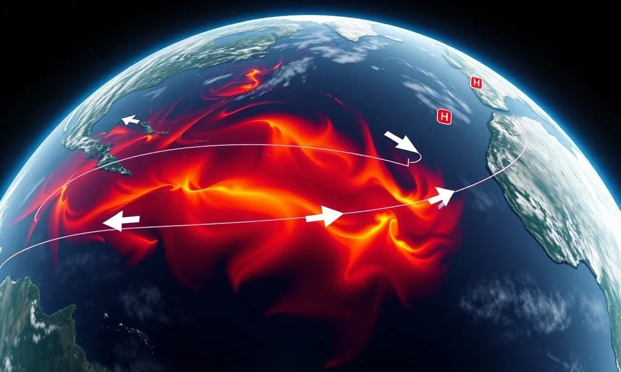
This surge is driven by a weakening of the trade winds—the planetary engines that usually keep warm water bottled up in the west. As these winds falter, a “Kelvin Wave” of warm water is surging across the ocean, destined to crash into the South American coastline. This isn’t just a localized warming; it’s a global energy transfer that disrupts the jet stream, moving it like a ribbon in a gale.
The data below illustrates the probability shift we’ve seen in just the last few months, showcasing how quickly the “Super” status has moved from a fringe theory to a statistical likelihood:
| Forecast Period (2026) | La Niña Probability | Neutral Probability | El Niño Probability |
|---|---|---|---|
| March – May | 25% | 65% | 10% |
| June – August | 2% | 36% | 62% |
| September – November | 1% | 19% | 80% |
The Boiling Depths: Tracking the Hidden Heat Wave Beneath the Waves
While most of us look at the surface, the real story of the Super El Niño 2026 weather impacts is being written hundreds of meters below. Satellite altimetry has detected a significant “bulge” in the sea level across the eastern Pacific—a clear indicator that the water column is expanding due to intense heat. This subsurface heat reservoir is the “fuel tank” for the upcoming weather shift.
This subterranean warmth is currently moving at a rate that suggests the peak of this event will hit in late 2026, potentially rivaling the historic 1997 and 2015 “Godzilla” El Niños. Because the ocean has been absorbing excess greenhouse gas heat for decades, this particular event is starting from a much higher baseline, making the potential for record-breaking temperatures 2026 forecast almost a mathematical certainty.
To visualize the vertical heat distribution, imagine the following cross-section of the Pacific Ocean temperature anomalies:
 PACIFIC TEMPERATURE ANOMALY PROFILE (DEPTH) Depth (m) |  West  |  Central  |  East0m        | [Normal]| [Warm]    | [HOT!!!]
100m      | [Cool]  | [WARM]    | [HOT!!]
200m      | [Cool]  | [Warm]    | [Warm]
300m      | [Stable]| [Stable]  | [Stable]
The Atlantic’s Invisible Armor: Is This the Hurricane Season’s ‘Natural Shield’?
In a twist of atmospheric irony, the same phenomenon that brings drought to the Amazon and heatwaves to Australia might actually save the US East Coast from a nightmare hurricane season. This is the “Natural Shield” effect. As El Niño warms the Pacific, it creates powerful westerly winds high in the atmosphere that blow across the Atlantic. These winds act like a giant pair of scissors, cutting off the tops of developing tropical storms before they can become monsters.
This “vertical wind shear” is the mortal enemy of hurricanes. While the Atlantic waters themselves are at record warmth—which usually fuels storms—the Super El Niño could provide a much-needed atmospheric brake. It is a battle of giants: record ocean heat versus record wind shear. For residents from Florida to Maine, this shield could be the difference between a catastrophic season and a manageable one.
However, NewsBurrow warns against complacency. Even in El Niño years, a single storm that finds a “gap” in the wind shear can become a devastating hurricane. The shield is strong, but it is not impenetrable. We are tracking a delicate balance that could shift with the slightest change in the Pacific’s pulse.
North America Under Pressure: A Continental Split in the Summer Sun
The Summer 2026 Super El Niño forecast suggests a North America divided. According to the latest pressure mapping, a persistent low-pressure trough is expected to settle over the Eastern United States and Canada. This typically translates to cloudier, cooler, and wetter conditions for the Atlantic provinces and the Northeast, offering a strange reprieve from the global heat trend.
Conversely, the Pacific Northwest and Western Canada are bracing for a “Heat Dome” scenario. With high-pressure ridges expected to lock into place, cities like Seattle, Vancouver, and Portland could face prolonged periods of stagnant, blistering air. This pressure “seesaw” is a classic signature of a powerful ENSO shift, but the magnitude of the 2026 event suggests these anomalies will be far more extreme than in previous decades.
Farmers in the Midwest are already expressing concern. While the “shield” helps the coast, the shifting jet stream could mean erratic rainfall patterns in the Corn Belt. We are looking at a summer where one half of the continent might be sandbagging against floods while the other half is fighting wildfires. It is a continental identity crisis written in the clouds.
Europe’s Stratospheric Gamble: The QBO Connection and the Scorching South
Across the Atlantic, European meteorologists are looking even higher—into the stratosphere. The Quasi-Biennial Oscillation (QBO), a belt of winds high above the equator, is currently in a phase that, when combined with a Super El Niño, historically leads to intense high-pressure “blocking” over the UK and Scandinavia. This setup is a recipe for the kind of “Omega Blocks” that trap heat for weeks on end.
The Mediterranean, already reeling from successive years of drought, may face its most challenging summer yet. With the jet stream pushed northward, the cooling Atlantic breezes will likely bypass Spain, Italy, and Greece entirely, leaving them vulnerable to Saharan heat plumes. This isn’t just “summer weather”; it is a systemic shift that threatens local agriculture and tourism economies.
The convergence of the QBO shift and the El Niño surge creates a “perfect storm” for European climate patterns. If these two variables lock into sync as predicted, we could see temperature records from 2022 and 2023 fall before the autumn leaves begin to turn.
The 1.5°C Breaking Point: Why 2026-2027 Will Haunt the History Books
We are standing on the precipice of a terrifying milestone. The World Meteorological Organization has warned that the combination of human-induced warming and the Super El Niño of 2026 will almost certainly push the global average temperature past the 1.5°C warming threshold on a temporary basis. While this doesn’t mean we’ve permanently failed the Paris Agreement, it is a flashing red light for the planet’s health.
The “shock factor” here is the speed of the climb. We aren’t just edging toward new records; we are leaping over them. The heat energy being released by the Pacific during this transition is equivalent to millions of Hiroshima-sized bombs every day. This energy doesn’t just disappear; it manifests as extreme weather, melting glaciers, and dying coral reefs.
For the average citizen, this means the “once-in-a-lifetime” weather event is becoming the “once-a-summer” occurrence. The year 2026 is shaping up to be the year that the abstract concept of “climate change” becomes a visceral, daily reality for the global population. The forecast is no longer about whether it will be hot, but how we will survive the heat.
The Arctic’s Final Defense: Alaska’s Vanishing Ice and the Erosion Crisis
While the world focuses on tropical heat, the Arctic is experiencing a quiet catastrophe. The sea ice that traditionally protects Alaska’s northern and western coastlines is vanishing at a rate that has left local communities defenseless. Without the ice to act as a buffer, the massive storms stirred up by the Super El Niño are slamming directly into the permafrost-heavy shores, literally washing towns into the sea.
This is a regional climate pattern shift with global consequences. As the ice melts, the “Albedo Effect”—where ice reflects sunlight back into space—is lost. The dark ocean water absorbs more heat, creating a feedback loop that accelerates the warming even further. Alaska is the “canary in the coal mine,” and right now, that canary is losing its perch.
Current observations indicate that the sea ice season in the Beaufort and Chukchi Seas has shortened by nearly six weeks compared to the 1980s. This isn’t a slow decline; it’s a collapse. For the indigenous populations of the North, the 2026 weather shift isn’t a headline—it’s an existential threat to their ancestral lands.
Economic Shockwaves: From Your Morning Coffee to the Global Energy Grid
The Super El Niño isn’t just a weather story; it’s a business story. Historically, powerful El Niños have sent shockwaves through the global commodities markets. Brazil, a powerhouse for coffee and sugar, often faces erratic rainfall during these events, while Southeast Asian palm oil production can be decimated by drought. You will likely feel the 2026 weather shift in your grocery bill before you feel it on your skin.
Energy grids are equally at risk. In South America, where hydroelectric power is king, drought can lead to massive blackouts and soaring energy prices. In the Northern Hemisphere, the demand for air conditioning during the predicted 2026 heatwaves will push aging electrical grids to their absolute breaking points. We are looking at an era of “climate-driven inflation” that central banks are struggling to model.
Investment trends are already shifting toward “weather-resilient” infrastructure. Smart money is moving into water purification, localized energy storage, and drought-resistant agricultural tech. The 2026 forecast is a wake-up call for the global economy: adapt or be swept away by the changing tide.
The Proactive Path: Navigating the 2026 Atmospheric Reset
As we move through the “Spring Predictability Barrier,” the clarity of our climate future is improving daily. While the news is daunting, knowledge is the ultimate survival tool. We are no longer blind to these cycles; we can see the Super El Niño coming from thousands of miles away and months in advance. This gives us a window—short as it may be—to prepare.
Communities must prioritize infrastructure resilience, and individuals should stay informed through verified channels like NewsBurrow. The 2026 atmospheric reset is a reminder of our planet’s power and our own vulnerability. It is a time for global cooperation, as the weather knows no borders and respects no treaties.
What do you think about the upcoming weather shift? Are you seeing changes in your local environment already? We want to hear your stories and your concerns. Join the conversation in the comments below and let’s discuss how we can weather this coming storm together. The Pacific has spoken; now it’s our turn to listen and act.
As the Pacific Ocean undergoes this historic thermal reset, the margin for error in personal preparedness is shrinking. Meteorologists at NewsBurrow emphasize that while high-level data helps us understand the global shift, localized weather volatility—ranging from sudden “Heat Domes” to erratic storm cells—will be the defining feature of the Summer 2026 Super El Niño forecast. Relying solely on cellular networks during these atmospheric disruptions can be a gamble, as extreme conditions often push local infrastructure to its breaking point.
To navigate this unpredictable new climate reality, having independent access to real-time emergency broadcasts is no longer a luxury; it is a critical safety requirement. We have analyzed the most reliable tools currently available to help you maintain a continuous link to National Weather Service updates, even when the grid falters under the weight of record-breaking temperatures. Ensuring your household is equipped for rapid-onset weather changes is the first step in moving from climate vulnerability to climate resilience.
We invite you to join the conversation in the comments below—how is your community preparing for the 2026 surge? For exclusive deep dives into regional climate survival strategies and breaking ENSO updates, be sure to subscribe to the NewsBurrow newsletter. Explore our top-tier recommendations below to ensure you and your family stay informed and protected as the Super El Niño takes hold.
Shop Products On Amazon
Shop Products on Ebay
Trending Similar Stories in the News
Trending Videos of Summer 2026 Super El Niño Forecast
GIPHY App Key not set. Please check settings