Table of Contents
Nebraska School Closures Winter Storm
Nebraska School Closures: Winter Storm Warning Triggers Massive Cancellations Across Omaha & Lincoln
Nebraska school closures winter storm updates are flooding in as Omaha, Lincoln, and Bellevue districts cancel classes ahead of a predicted 8-inch snowfall.
The Great Freeze of 2026: Nebraska Braces for a Mid-Winter Polar Pivot
By Aiden Hughes | @AidenReports | NewsBurrow News Network
The sky over the Cornhusker State has turned a heavy, bruised gray, signaling the end of a bizarre spring-like intermission. Just forty-eight hours ago, residents in Omaha and Lincoln were basking in unseasonable highs near 70°F, a record-shattering reprieve that felt more like early May than mid-February. But as of Thursday morning, February 19, 2026, the atmosphere has staged a violent coup. A deep low-pressure system is currently muscle-flexing its way across the Plains, dragging a curtain of arctic air that is turning rain to ice and optimism to emergency preparation.
This isn’t just a dusting of snow; it is a tactical shutdown of the state’s infrastructure. From the Panhandle to the Missouri River, the “Great Freeze of 2026” has arrived with a howling wind that moans against windowpanes like a ghost with a grudge. For thousands of families, the morning coffee was accompanied by the frantic ping of smartphone alerts: Omaha Public Schools, Lincoln Public Schools, and Bellevue have all officially hoisted the white flag, canceling classes as a Winter Storm Warning settles over two dozen counties. The narrative of the season has shifted in a heartbeat from “early spring” to “survival mode.”
The stakes are particularly high for those in the north-central regions, where a concentrated band of moisture is expected to dump a staggering 8 inches of “heart-attack snow”—heavy, wet, and unforgiving. As the National Weather Service (NWS) issues dire warnings about “very difficult” travel, the quiet that usually precedes a storm has been replaced by the roar of snowplows being prepped and the rattle of grocery carts filled with the essentials of a lockdown. At NewsBurrow, we are tracking every flake and every closure to keep you ahead of the drift.
The Impact Zone: A Tale of Three Metros and the Rural Divide
The geographic split of this storm is creating a logistical nightmare for state officials. While the Omaha metro is bracing for 4 to 6 inches, the “bullseye” has shifted toward Columbus and Ord, where totals could peak at 8 inches. This discrepancy isn’t just a matter of numbers; it’s a matter of resources. In the city, a 6-inch snowfall slows the commute; in the rural expanses of Custer County and the Sandhills, it can bury a landscape and isolate farms for days. The NWS Hastings office has noted that the heaviest snow band is remarkably narrow—only about 40 to 60 miles wide—meaning a slight shift in the storm’s track could mean the difference between a minor nuisance and a catastrophic burial.
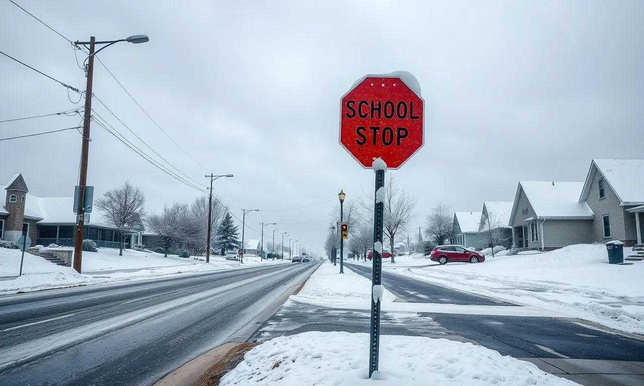
School administrators didn’t wait for the first flake to make their move. By 9:00 a.m. Thursday, the list of closures had grown into a roll call of Nebraska’s educational backbone. The decision to shutter schools is never taken lightly, involving a complex calculus of bus route safety, parking lot clearance, and the dreaded “black ice” factor as temperatures are expected to plummet into the teens by nightfall. Below is a snapshot of the current status of Nebraska’s educational hubs:
| District/Institution | Status (Feb 19, 2026) | Forecasted Impact |
|---|---|---|
| Omaha Public Schools (OPS) | CLOSED | 4-6 Inches / Wind Gusts 40mph |
| Lincoln Public Schools (LPS) | CLOSED | 1-3 Inches / Flash Freeze Alert |
| Bellevue Public Schools | CLOSED | 4-6 Inches / Heavy Accumulation |
| Columbus Public Schools | CLOSED | 5-8 Inches / Whiteout Conditions |
| Chadron State College | CAMPUS CLOSED | Extreme Cold / Prior Snow Pack |
The Whiplash Effect: From Sunsets to Snowdrifts
What makes this storm particularly dangerous is the “weather whiplash” Nebraskans are currently experiencing. We’ve just come off a seven-day streak of highs exceeding 60°F in the metro areas—a warmth that fooled the local flora and perhaps lowered the guard of many residents. This sudden transition creates a psychological hurdle; people who were wearing light jackets on Tuesday are now scrambling to find buried ice scrapers and heavy parkas. The rapid drop in temperature—from the 40s at noon to the 20s by sunset—means that any slush created by early precipitation will flash-freeze into a lethal layer of “black ice” just as the evening commute peaks.
Meteorologists are pointing to a “deepening low” over the region, a phenomenon that acts like a vacuum, sucking in moisture and spinning it out as intense snow bands. Under these bands, snow can fall at a rate of 1 to 2 inches per hour, effectively blinding drivers and overwhelming salt trucks. The ASCII art below illustrates the predicted snowfall intensity across the state’s central corridor as the storm reaches its peak intensity between 3:00 p.m. and 9:00 p.m. Thursday.
NEBRASKA SNOWFALL INTENSITY GRADIENT (FEB 19, 2026)[HEAVY] ************************** (8" - Ord/Columbus) [MEDIUM] ****************** (6" - Omaha/Elkhorn) [LIGHT] ********** (2" - Lincoln/York) [FRIGID] ***** (1" - Sidney/Panhandle) (Each '*' represents approx. 0.3 inches)
Rural Survival: Navigating the 8-Inch Whiteout
For our readers in the Sandhills and north-central counties, this storm represents a significant threat to livestock and personal safety. When you combine 8 inches of fresh powder with northwesterly gusts of 40 mph, you get “ground blizzards.” These occur when fallen snow is whipped into the air, reducing visibility to zero even if it has stopped snowing. In these conditions, landmarks vanish, and even seasoned Nebraska drivers can find themselves disoriented on a familiar section of Highway 2 or US-30.
If you are a rural commuter or property owner, the standard “emergency kit” needs an upgrade for a storm of this magnitude. It isn’t just about a flashlight anymore; it’s about ensuring you have enough fuel for generators and clear paths to livestock. The timing of this storm is a “perfect storm” of inconvenience—hitting right as the workday ends and darkness falls, complicating rescue efforts if a vehicle slides off the road.
- The 10-Minute Rule: If stranded in your vehicle, run the engine for only 10 minutes every hour for heat, ensuring the exhaust pipe is clear of snow to prevent carbon monoxide poisoning.
- The Traction Trick: Keep a bag of kitty litter or sand in your trunk. A small amount under the tires can provide the friction needed to escape a slick ditch.
- Device Discipline: Charge all external power banks now. In the event of a power outage, your smartphone is your primary link to emergency services and NWS updates.
The Interstate 80 Nightmare: A Gridlock in the Making
The “Main Street of Nebraska”—Interstate 80—is the focal point of the state’s economic and travel anxiety. As the snow transitions from wet to fluffy, the wind will begin to sculpt massive drifts across the east-west artery. The Nebraska Department of Transportation (NDOT) has already deployed hundreds of plows, but their efforts are often stymied by the sheer volume of traffic. A single jackknifed semi-truck near the Platte River bridge can trigger a chain reaction of gridlock that leaves hundreds of travelers stranded in sub-freezing temperatures.
Authorities are urging everyone to “reconsider non-essential travel.” This is a polite way of saying: if you don’t need to be on I-80, stay home. The risk of being caught in a multi-vehicle pileup is statistically highest during the transition period when rain turns to ice. By 6:00 p.m., the roads are expected to be “completely covered” across the York to Omaha stretch. For those who must travel, the NDOT’s 511 map is the only map that matters today.
Cold Realities: The Frigid Weekend Ahead
Once the snow stops falling late Thursday night, the secondary threat arrives: the cold. This storm is the vanguard of an arctic air mass that will pin temperatures in the 20s and 30s through the upcoming weekend. The “slush” from today will become the “concrete” of tomorrow. For city residents, this means that if you don’t shovel your sidewalk before the temperature drops tonight, you will be chipping away at solid ice for the next three days.
Warming centers are being activated in Lincoln and Omaha for those without adequate heating, as wind chills are expected to dip into the single digits. This is a stark reminder of the vulnerability of our infrastructure during extreme weather events. While the snow is the headliner, the cold is the lingering antagonist that will test our power grids and plumbing through Sunday.
The NewsBurrow Perspective: A Shock to the System
At NewsBurrow, we believe this storm is more than just a weather event; it is a critique of our modern preparedness. In an era of high-speed digital alerts, why do we still see hundreds of motorists stranded on I-80 every time the clouds turn dark? There is a “shock factor” here: despite our advanced forecasting, nature still possesses the power to humiliate our technology. We are currently witnessing a state-wide “pause” button being pressed, reminding us that for all our growth, we are still at the mercy of the jet stream.
We want to hear from you. How is your district handling the storm? Did the closures come early enough, or were you caught in the midday scramble? This storm is a conversation about safety, infrastructure, and community. Join the discussion on our social channels using #NebraskaSnow2026 and share your “front-line” photos and stories. Stay warm, stay inside, and keep your radios tuned to the frequency of survival.
As the “Great Freeze of 2026” tightens its grip across the Omaha and Lincoln metros, the sudden shift from record warmth to a life-threatening winter storm warning serves as a sobering reminder of Nebraska’s unpredictable climate. With school districts shuttered and the National Weather Service cautioning against “very difficult” travel, the safety of your family during this 8-inch snowfall depends entirely on proactive preparation. Whether you are navigating the slushy corridors of I-80 or hunkering down in a rural farmhouse, having the right supplies on hand can transform a potential disaster into a manageable inconvenience.
The transition from a cozy 60°F afternoon to a single-digit wind chill is exactly when most Nebraskans find themselves caught off guard, often realizing too late that their seasonal supplies are buried in the garage or depleted. To help you bridge the gap between “weather whiplash” and total readiness, we have curated a selection of professional-grade essentials designed to withstand the harshest Plains blizzards. These tools are the backbone of a resilient household and are specifically chosen to address the unique challenges of the current storm trajectory.
Don’t wait for the power to flicker or the drifts to reach your door before securing your peace of mind. We invite you to explore the essential gear below to ensure your vehicle and home are fortified against the freezing days ahead. After you’ve geared up, join the NewsBurrow community by sharing your own storm-prep tips in the comments and subscribing to our newsletter for real-time alerts and exclusive safety insights delivered straight to your inbox.
Shop Products On Amazon
Shop Products on Ebay


Trending Similar Stories in the News
Omaha-area schools, businesses change schedules for Thursday's snowy forecast KETV...
Nebraska schools shut down as 8 districts close Rolling Out...

GIPHY App Key not set. Please check settings