Table of Contents
Boston Winter Storm 2026
Boston Winter Storm 2026: Historic 20-Inch Snowfall Forecast to End Years-Long Snow Drought
Boston winter storm 2026 is set to shatter a four-year snow drought as forecasters warn of a massive system capable of dumping over a foot of snow across the city.
By Aiden Hughes (@AidenReports)A City Under Siege: The Great Snow Drought of the 2020s Meets Its MatchBoston is a city defined by its grit, its history, and—usually—its punishing winters. Yet, for the better part of the last four years, the shovels have stayed in the garage and the salt has gathered dust. A bizarre “snow drought” has gripped the Hub since early 2022, leaving residents more accustomed to mild, slushy Januarys than the legendary whiteouts of old. But the sky is about to settle the score.The NewsBurrow Press Team has been monitoring a massive, arctic-charged system currently churning across the continental United States. Meteorologists are no longer whispering about “potential accumulation”; they are shouting about a historic event. Starting Sunday morning, January 25, 2026, a monster storm is projected to collide with a wall of frigid air, threatening to dump 12 to 20 inches of snow on a city that has forgotten what a true blizzard feels like.This is not just another winter advisory. This is the first major winter storm in years with the atmospheric muscle to bury the South End and paralyze the Pike. With the “drought” finally breaking, the shock factor isn’t just the depth of the snow, but how quickly Bostonians must pivot back into survival mode.Echoes of 2022: Why This Nor’easter Is a Generational ReckoningTo understand the weight of this forecast, one must look back to January 29, 2022. That was the last time the city felt the true crush of a foot-plus storm. Since then, the Northeast has experienced a meteorological anomaly—a series of “misses” and rain-heavy systems that spared the infrastructure but altered the local psyche. We’ve grown soft, and Mother Nature has noticed.The NewsBurrow Network’s analysis of historical data reveals a stark contrast in our recent winter reality. While 2023 and 2024 saw negligible totals, the 2026 system is trending toward the “jackpot” category. The sheer volume of cold air preceding this storm means we aren’t just looking at snow; we are looking at a landscape-altering event.
| Year | Max Single-Storm Snowfall (inches) | Notes |
|---|---|---|
| 2022 | 23.6 | The Last Great Blizzard |
| 2023 | ~3.5 | Mild Winter Records |
| 2024 | ~2.8 | Frequent Rain Events |
| 2025 | ~5.3 | The “Drought” Peak |
| 2026 (Forecast) | 12.0 – 20.0 | The Drought Breaker |
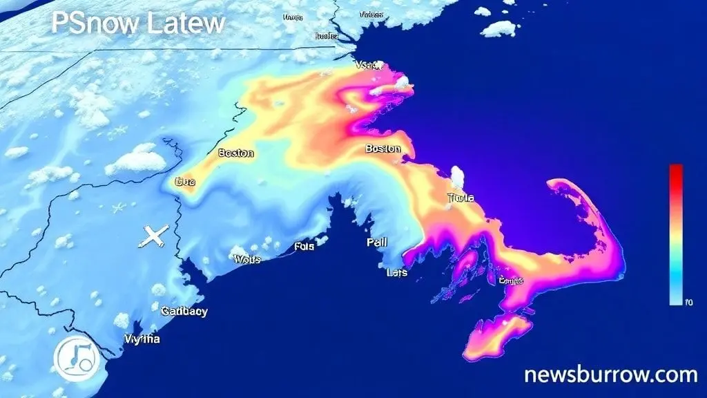
Mayor Wu’s Cold Emergency: A City Standing on High AlertOn Thursday evening, Mayor Michelle Wu officially triggered the “Cold Emergency” protocol for the City of Boston, effective through Sunday night. This isn’t merely a bureaucratic formality; it’s a mobilization of resources designed to prevent loss of life in a city facing wind chills that could plummet to -10°F even before the first snowflake hits the ground.The NewsBurrow Press Team can confirm that Boston Centers for Youth & Families (BCYF) are being converted into emergency warming centers. For those in the most vulnerable sectors of our population—the elderly, the homeless, and the young—the city is maintaining a “zero-refusal” policy at shelters. “Our departments are working around the clock,” Mayor Wu stated, her tone reflecting the gravity of the incoming arctic blast.Street outreach teams have been doubled, and the Boston Police Department is conducting wellness checks in every neighborhood. This proactive stance is a direct response to the “shock” of the sudden temperature drop, transitioning from a mild January to a life-threatening freeze in less than 48 hours.The Physics of Fluff: Understanding the 20:1 Snow RatioNot all snow is created equal. The storm of 2026 is bringing what meteorologists call “high-ratio snow.” While typical New England storms often feature a 10:1 ratio (ten inches of snow for every inch of rain), the arctic air currently locked over Massachusetts is pushing us toward a 20:1 ratio.This means the snow will be light, powdery, and incredibly deep. While it may be easier to shovel initially, it is a nightmare for visibility.Visibility: Winds gusting to 50 mph will catch this “fluff,” creating whiteout conditions even when the snow isn’t falling heavily.Drifting: Expect snowbanks to climb over 4 feet high in wind-exposed areas like East Boston and the Seaport.Power Lines: While light snow is less likely to snap branches than “wet” snow, the sheer volume and accompanying gale-force winds still put the grid at risk.PlaintextPROJECTED SNOW ACCUMULATION GRADIENT (Inches)
|
| 20″ + [**********] <- North Shore / Cape Ann | 18" [******** ] <- Downtown Boston / Cambridge | 15" [******* ] <- MetroWest / Worcester | 12" [****** ] <- South Shore / Plymouth | 6" [*** ] <- Cape Cod (Mixing likely) |______________________ REGION Sunday Morning Lockdown: The Timeline of a Total WhiteoutThe clock starts ticking Sunday morning. The NewsBurrow Network tracking suggests the leading edge of the storm will cross the Connecticut border around 8:00 AM, reaching the 128 belt by mid-morning. This is a long-duration event—a marathon, not a sprint—lasting well into Monday afternoon.By Sunday evening, the intensity is expected to peak. We are talking about snowfall rates of 1 to 2 inches per hour. This is the window where road crews lose the battle. If you are not where you need to be by 2:00 PM on Sunday, you are likely staying put until Monday night. The duration of this storm is what makes it dangerous; it exhausts the plows and limits the ability of emergency vehicles to respond to calls.Grounded: Logan Airport and the MBTA Service CrisisTravel will be, quite simply, impossible. Logan Airport is already bracing for a wave of cancellations that could mirror the 18,000-flight meltdown of December 2022. The NewsBurrow Press Team advises all travelers to check their status before even heading to the airport, though most major carriers have already issued travel waivers for the weekend.The MBTA, meanwhile, faces a unique challenge. With Blue Line service already scheduled for tunnel inspections between Bowdoin and Airport stations, the shuttle bus replacements are expected to be mired in the rising drifts.Commuter Rail: Expect "Slippery Rail" protocols and significant delays on the Fitchburg and Haverhill lines.Subway: Outdoor sections of the Red and Orange lines are susceptible to third-rail icing.Ferries: Service to Hingham, Hull, and Charlestown is almost certain to be suspended by Sunday morning due to sea states and high winds.Beyond the Shovel: Protecting Your Home from the Deep FreezeWhen the snow stops, the real danger begins: the freeze. With temperatures falling into the single digits, the risk of burst pipes is at a four-year high. NewsBurrow.com recommends residents locate their main water shut-off valve immediately."If a pipe bursts, you have seconds to act before your basement becomes a skating rink," warns our local infrastructure expert. Open your cabinet doors to let warm air circulate around plumbing, and keep a thin trickle of water running in faucets located on exterior walls. The city's Inspectional Services Department (ISD) is adding staff to handle the inevitable surge in heating complaints and emergency repairs.A New Winter Reality: Join the ConversationThis storm is more than a weather event; it is a reminder that Boston remains at the mercy of the Atlantic and the Arctic. As the 2026 Nor'easter moves in to break the snow drought, the community's resilience will be tested. Will our infrastructure hold? Have we forgotten how to drive in a true whiteout?We want to hear from you. How are you preparing for the "Big One"? Are you stocked up on the basics, or are you skeptical of the 20-inch forecast? Share your storm photos, your survival tips, and your "space saver" stories with us on social media using #BostonSnow2026 and join the discussion on NewsBurrow.com. Stay warm, stay safe, and stay informed.
As the first flakes begin to settle and the wind picks up across the Commonwealth, the reality of a 20-inch accumulation is setting in for millions of residents. The transition from a multi-year snow drought to a major blizzard requires more than just mental readiness; it demands the right physical tools to ensure your property remains accessible and safe. Waiting until the drifts are waist-high to realize your current equipment is inadequate could leave you stranded and exhausted in sub-zero temperatures.
Our team at NewsBurrow Network has analyzed the unique “fluff factor” of this incoming arctic system, noting that while the snow is light, the sheer volume will require high-efficiency tools to clear effectively. Whether you are maintaining a narrow city sidewalk in the North End or a sprawling driveway in MetroWest, having professional-grade gear is the difference between a quick morning chore and a day-long struggle. Being proactive now ensures that you aren’t left scouring empty local shelves once the state of emergency is fully underway.
Before the heaviest bands of the storm lock down the city, we have curated a selection of top-rated winter essentials that are built to handle the heavy-duty demands of a historic New England winter. We invite you to share your storm preparation tips in the comments below and subscribe to the NewsBurrow newsletter for real-time weather updates and exclusive local guides. Explore our expert recommendations to find the perfect match for your snow-clearing needs today.
Shop Products On Amazon
Shop Products on Ebay
Trending Similar Stories in the News
Trending Videos of Boston Winter Storm 2026
GIPHY App Key not set. Please check settings